|
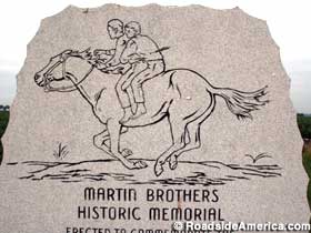
ALDA- Martin Brothers Historic Memorial
The Martin brothers, Nat age 15 and Bob age 12, were returning home with a load of hay when they were attacked by a party
of Sioux and Cheyenne in August 1864. The boys jumped onto a horse and fled, with Nat holding onto Bob. The Indians followed
and shot Nat twice with arrows, once in his elbow and once in his side. The second arrow had enough velocity to continue through
Nat and lodge in Bob's back. The boys, pinned together, tumbled off of the horse and were left for dead.
They did not die. Nat and Bob eventually, and no doubt awkwardly, made their way to a doctor and were unpinned. Bob survived
into middle age -- although he always had a bad back-- and Nat died as an old man.
Monument: Where Brothers Were Pinned Together By An Arrow
Address: Alda Road, Alda, NE
Directions:
I-80 exit 306, then south three miles on Hwy 26/Alda Rd. On the right side, at the intersection of Platte River Rd.

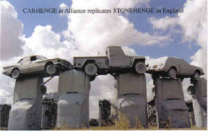
ALLIANCE-CARHENGE
Carhenge, which
replicates Stonehenge, consists of the circle of cars, 3 standing trilithons within the circle, the heel stone, slaughter
stone, and 2 station stones, and the Aubrey circle, named after Sir John Aubrey who first recognized the earthworks and great
stones as a prehistoric temple in 1648. It was not until excavations undertaken in the 1920's that they were found to
be holes cut to hold timber uprights. A total of 56 holes were discovered and named the Aubrey Holes in honor of John Aubrey's
observation.
The artist of this
unique car sculpture, Jim Reinders, experimented with unusual and interesting artistic creations throughout his life. While
living in England, he had the opportunity to study the design and purpose of Stonehenge. His desire to copy Stonehenge in
physical size and placement came to fruition in the summer of 1987 with the help of many family members.
Thirty-eight automobiles
were placed to assume the same proportions as Stonehenge with the circle measuring approximately 96 feet in diameter. Some
autos are held upright in pits five feet deep, trunk end down, while those cars which are placed to form the arches have been
welded in place. All are covered with gray spray paint. The honor of depicting the heel stone goes to a 1962 Caddy.
Carhenge was built
as a memorial to Reinders' father who once lived on the farm where Carhenge now stands. While relatives were gathered following
the death of Reinders' father in 1982, the discussion turned to a memorial and the idea of a Stonehenge replica was developed.
The family agreed to gather in five years and build it. The clan, about 35 strong, gathered in June 1987 and went to work.
They held the dedication on the Summer Solstice in 1987, with champagne, poetry, songs and a play written by the family.
Carhenge has been
preserved by Friends of Carhenge, a local group, who now owns and maintains it. Reinders donated the 10 acres of land
where Carhenge is located. They have added a paved parking lot, picnic tables, and an educational display board.
Additional sculptures
have been erected at the site, known as the Car Art Reserve. One of the first sculptures to be added to the Car Art Reserve
is a sculpture of a spawning salmon created by 29 year-old Canadian Geoff Sandhurst. Sandhurst won a $2500 prize and placement
of his car art creation at the Reserve.
Reinders' "Ford
Seasons", comprised only of Fords and inspired by Vivaldi's Four Seasons, suggests the Nebraska landscape's seasonal changes
as wheat is planted, grows, is harvested, and then the field lies barren during a windy winter.
Carhenge's uniqueness,
novelty and unusual components continue to draw the attention of film and television production crews as well as over 80,000
tourists from all over the world. All but 19 of the Aubrey holes have been developed, and those wishing to install a hole
may do so upon application to Friends of Carhenge.
AUBURN- Half-Breed Tract
It was an accepted custom for many
early fur traders to marry into Indian tribes. As the Indians ceded their lands, the rights of the half-breed descendants
were not always identified. This situation was recognized by the government in 1830, by the Prairie Du Chien Treaty which
set aside a tract of land for the half-breeds of the Oto, Iowa, Omaha and Santee Sioux tribes.
This tract was located between the Great and Little Nemaha Rivers. In 1838, the land was surveyed by John C. McCoy, who
placed the western boundary eight miles west of the river instead of ten miles as specified. This caused problems, as later
white settlers were to settle on Indian lands west of McCoy's line. Congress ordered the land resurveyed, and in 1858 the
McCoy line was made official. On September 10, 1860, Louis Neal received the first patent.
The owners were never required to live on their property and many eventually sold their lands to whites. One of the original
survey lines is now partly identified by the Half-Breed Road which runs in a southeast direction from here. The descendants
of some pioneer fur traders still live in the area.
Auburn Community Betterment Council
Historical Land Mark Council
US 136, east of Auburn
Nemaha County
Marker
58
COMSTOCK - Dowse Family Sod House
The Dowse Family Sod House was built by pioneers in 1900. In the 1800's, many pioneers needed
to build adequate houses, but the shortage of timber caused problems. The pioneers figured out that they could cut the
thich, heavy sod, native to Nebraska, and cut it into squares. They would then stack these squares of sod into walls
and anchor them together. These houses turned out to be better houses than their wood counterparts. This was due
to their natural insulating qualities. Sod houses were cooler in the summer and insulated better from the bitter winter
cold and winds. The were also fireproof, which was a plus due to all of the fires that commonly swept through the open
praries. If you have never seen a sod house, it is worthwhile to take a look into the past and the history of our country.
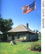
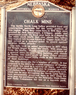 ELBA - Happy Jack Chalk Mine
Happy Jack Chalk Mine was started in 1877 to mine chalk out of the hillside near present
day Scotia. It was named for Jack Swearegen, an early settler in the area. He was said to be very friendly and
helpful to his neighbors. Therefore, he received the nickname "Happy Jack." The mine operated until
the end of World War II. You can now take tours of the min for a minimal fee. It is the only chalk mine in the
U.S.. It is an example of room and pillar mining. There are over 6000 feet of underground tunnels of all sizes.
You can also climb to the top of Happy Jack Peak (the mine is below you) and look at the spectacular view of the North Loup
River winding its way through the gently rolling sandhill scenery. Happy Jack Chalk Mine is located about 12 to 15 miles
north of Elba, Nebraska on Highway 11. It is open from Memorial Day to Labor Day for tours.
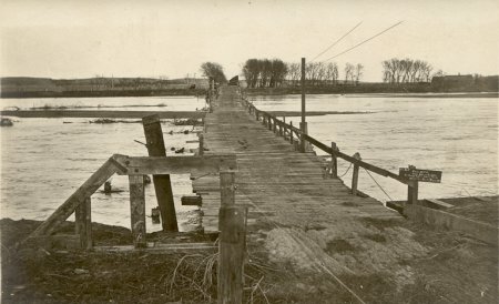
|
| Bridge near Elba |
ELI- Petrified Wood Gravemarkers
Eli is west of Valentine, a mile north of Highway 20 in the northern Nebraska Sandhills. Eli has about a dozen houses,
a church, and a general store, plus a windmill graveyard on the edge of the hamlet. Inquire at the store for directions to
the Conley Flats Cemetery, south and east of Eli some 8 miles. The cemetery, located on a picturesque table overlooking
the Niobrara River valley, has quite a few grave markers formed of petrified wood, particularly the Bigelow
family plot.
FAIRFIELD - Spring Ranche
The original Spring Ranche, located two miles south of here on the north side of the Little Blue River, was founded about
1863. James Bainter, the first permanent settler, operated a store and inn for travelers along the Oregon-California Trail.
The ranche was burned in 1864 when Lakota Sioux and their allies attacked settlements along the Little Blue. Spring Ranche
was later rebuilt.
The village of Spring Ranch dates from 1870 when a post office was established south of the river. A saw mill was in operation
a year later. In 1886 the townsite moved across the river, where the St. Joseph and Grand Island Railroad was being built.
The village once boasted several businesses and a population of about 100, but few traces remain today.
In 1885 Spring Ranch residents Elizabeth Taylor and her brother Thomas Jones were accused of barn burning and murder. Before
they could be tried, they were lynched by a mob on March 15. Taylor and Jones, along with other early settlers, are buried
in the Spring Ranch Cemetery.
Spring Ranche River Festival 1993
Nebraska State Historical Society
Oregon Trail Sesquicentennial
6 miles west
of Fairfield on Nebraska 74
Clay County
Marker 372
ELIJAH FILLEY STONE BARN - GAGE COUNTY
In 1867 Elijah Filley his wife Emma, their two sons, Fitch and Hiram and his father Ammi came to Gage County.
The family lived in a tent until they completed their seven rooms, 1 1/2 story stone dwelling in 1868. They called their new
home "Cottage Hill Farm".
In 1874 the farmers were in bad shape. They had two summers of drought, grasshopper invasion, and crop failure. Many
farmers were backing up and heading back east. Those that remained needed work. Elijah Filley chose this time to build his
barn. The news that Elijah Filley was building a barn spread fast. Men came from all over the area looking for work. Men who
lived too far away to drive home each night were quartered in tents.
The stone for the barn was hauled from Elijah's property near Rockford. The lime was hauled from Beatrice. Stone
piers were erected to hold the floor joist support beams from the interior. They are two feet square and the beams are one
foot square and extend the entire length of the barn. The main floor was laid of three-inch planks and the floor seams were
caulked with oakum, which was then covered with melted pitch. The oakum was made from hemp. All this was to make the floor
watertight. The lumber was hauled by ox team from Nebraska City.
By mid-October the walls went up. A row of decorative hand-carved narrower stone was placed around the barn
between the lower and second level. The walls on the first floor were two feet thick, and eighteen inches thick on the
two upper floors. The haymow floor joists were placed, and the stonework was completed on the tenth of November 1874.
The carpenters had the roof plates and rafters cut before the last stones in the walls were laid. All the workers
then helped with the rafters, nailing the sheeting and laying shingles. An eight-foot square cupola completed the barn.
The barn, which became a local landmark,
served its intended purpose for many decades. On April 11, 1977 the Stone Barn was listed on the National Register of Historic
Places. The following year, it was willed to the Gage County Historical Society by owner Edwin Pedersen, with over three
acres of the surrounding land and $10,000 for restoration. The Gage County Historical Society is continuing the restoration,
which was begun in 1980, as funds become available. An additional 20 acres were added in 1986. The exterior restoration
of the stone was completed in 1981. The Barn is presently open to the public on scheduled dates and for special events.
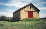
|
| Filley Stone Barn |
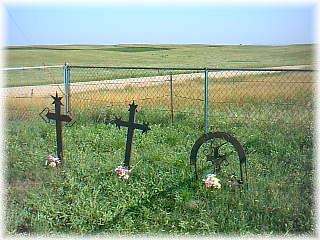
GOTHENBERG-Sweedish Crosses Cemetary
For over a century, three unique crosses have been a lasting symbol of the Swedish heritage of Gothenburg. In the early
1880s, Peter and Anna Berg, along with Anna's parents, the Benjamin Palms, came to Gothenburg from Helsingland, Sweden. Tragedy
struck the Bergs on their prairie homestead when their first child, Singne Ester, died July 21, 1885, four months after her
birth. Carl Alfred, their second child, died at the age of three months on September 14, 1886. Gustav Andrew, two years old,
died August 19, 1889. The three children were buried on a knoll near the family farm.
Markers for the graves were made in a traditional Swedish style by the children's grandfather, Benjamin A. Palm. Mr.
Palm was Gothenburg's first blacksmith.
He is reported to have sent to Sweden for some of the steel with which he fashioned the crosses. The distinctive crosses,
complete with elaborate scrollwork, hearts and stars, each carry a Swedish inscription of the children's names and their dates
of birth and death. The Bergs were blessed with four more children after the first three died.
A wrought iron fence forged by Mr. Palm to protect the graves has long since disappeared. The late Harry Williams of
Gothenburg began an effort to preserve the cemetery in the 1960s. With the aid of an anonymous donor and the Historical Trails
Committee, a chain link fence was erected in 1967.
Although the crosses have stood for over 100 years, several mysteries remain. The initials A.G. on one of the graves
stands for Andrew Gustav, but the family remembers he was called Gustav. What was the order of his formal name? On the back
of Singne's cross, the word Havilar is etched. Many tombstones and crosses in Sweden have this inscription. It translates
to "Here Rests". However, the other two crosses have the initials H.W. Do the initials mean the same? The causes of their
deaths have never been conclusive. Family stories tell of an epidemic that struck in the late 1800s. It is also believed several
neighboring children caught in a prairie fire are buried here without markers.
These unusual and artistic grave markers, wrought in Swedish steel by a loving grandfather, mark three children's graves--making
a small corner of Dawson County "forever Sweden." The Swedish Crosses Cemetery is one of Dawson County's historical sites.
A Nebraska Historical Marker was dedicated in August, 1991.
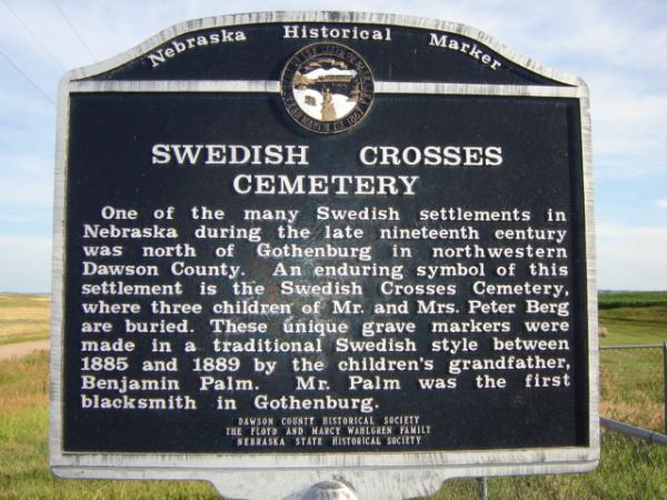
KIMBALL- Wheat Growers Hotel
The Wheat Growers Hotel was constructed in 1918 by F. Cunningham and was considered the "most glamorous Hotel between Omaha
and Denver". Dwight and Mami Eisenhower (with son Doug and Mami's parents) stayed at the Hotel in 1919. With 86 rooms, a restaurant
and a Ballroom, the Hotel became the hub for railroad travelers and locals alike.
Historic Wheat Growers Hotel
102 South Oak Street
Kimball, Nebraska 69145
KIMBALL COUNTY- Panorama Point
A tiny monument marks the highest elevation in Nebraska, 5424 ft above sea level with endless plains stretching
into the distance.
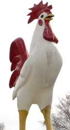
LINCOLN- Lee's Chicken
Lee's Chicken is a Lincoln legend with fantastic food and a cool giant chicken mascot! Also features a live piano layer
who takes your requests.
Address: 1940 W. Van Dorn, Lincoln, NE
Directions: I-80 exit 397. Drive south on US 77/Homestead Expressway for around 2.5 miles. Exit at Van Dorn St. and drive
east for one mile. On the right, at the corner of Coddington Ave.
Phone: 402-477-4339
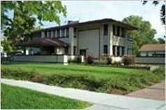
MC COOK - Frank Lloyd Wright House
One of America’s most influential and imaginative architects, Frank
Lloyd Wright spent almost 70 years creating a striking variety of architectural forms. It is one of the few homes west of
the Mississippi River designed by this internationally famous man. The Sutton House is an example of Wright’s prairie
style, in which he blended the structure with it’s natural surroundings. This fabulous home located at 602 Norris Avenue
is a private residence but may be viewed from Norris Avenue and West F Street.
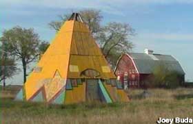
MILFORD - Westward Ho! Campground - Teepee
The so-called "teepee motel" west of Lincoln, NE on I-80 is actually the former Milford Inn, part of the "Westward Ho!
Campground" at the Milford exit and directly across the street from the World's Largest Covered Wagon. Kenneth Dahle, the
same man who constructed the covered wagon gas station, also owned the adjoining motel/campground property, on which he built
two large wooden teepees to attract motorists. One teepee contains a men's and women's restroom with showers, while the other
was once used as a spare motel room. Additionally, there are several Western-themed wooden decorations on the property such
as buffalo silhouette cutouts, campground markers shaped as arrowheads, and picnic tables with painted-on Indian symbols.
In the 1960s, Kenneth had an 1800's-era schoolhouse and church moved to the side of the road a few yards from the motel to
function as tourist attractions (easily visible from the site).
(Directions: I-80 Exit 382, about 20 miles west of Lincoln, NE )
MINDEN--Pioneer Village
You have to see it to believe it... The largest private collection of Americana anywhere. The Pioneer Village complex comprises
28 buildings on 20 acres housing over 50,000 irreplaceable items of historical value, restored to operating order, arranged
in groups and also in the chronological order of their development. There are 12 historic buildings around the circular "green".
There's a Frontier Fort, a real honest-to-goodness Pony Express Station, an Iron Horse, and a home made of sod. There's a
general store and a toy store, chock full of all the goods from yesteryear. An original art collection including 25 Currier
and Ives prints, 23 Jackson paintings, and the largest single collection of Rogers statues. You can ride a priceless steam
carousel, see 17 historic flying machines and marvel at 100 antique tractors. See a 1902 Cadillac and a 1903 Ford, both designed
by Henry Ford, plus 350 other antique cars, all displayed in their order of development. For a relaxing trip into yesterday,
come to Pioneer Village.
12 Miles South of I-80 from Exit 279
From I-80 Exit 279, take Harold Warp Memorial Drive (Nebr. Hwy 10) South to Minden.
Museum entrance is at the North
East corner of the intersection of US 6 & 34 and Nebr. Hwy 10.
Hours of operation:
We are open every day of the year, including all major Holidays, except Christmas Day.
Winter
hours: 9am- 4:30pm (7 days/week).
Summer hours: 8:00 am to 6:00 pm (Memorial Day weekend through Labor Day weekend).
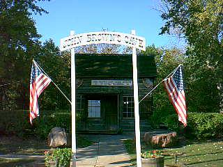
NEBRASKA CITY - John Browns Cave
John Kagi, one of abolishionist John Brown's most trusted collegues,
went to stay with his sister and brother-in-law Allen Mayhew. It was the early 1850's and the area was the Nebraska
City area of Nebraska. Their cabin was very close to the Missouri River. Across the river was Iowa and Missouri.
John Kagi, under the instruction of his friend John Brown, dug
an underground room underneath the Mayhew cabin. It was accessible only from a ravine leading into a creek. The
entrance was well camoflauged. There was also a hollow log put into the wall that lead to fresh air outside. This
helped the ventilation when the entrance was closed up. This cave was to be used as a stop on the Underground Railroad.
At night, slaves would cross the Missouri River from Missouri (slave
state) to Nebraska (free state). They would hide out in the cave for the night. Mrs. Mayhew would bring them cornbread.
After a short stay, they would be ferried across the Missouri River again. They would be taken a little more north to
Iowa (free state), to another stop on the Underground Railroad. Or else, as more recent evidence shows, they would proceed
toward Lincoln to hide out in Robber's Cave.
This cabin and cave are still standing where they were over a century
ago. The Mayhew cabin is said to be the oldest standing building in Nebraska.
 $6 for adults and $3 for children.
Group tours welcome. Group rates available.
Open every day April 1 - November 30
Mon-Sat 10am - 5pm
Sun Noon-5pm
NEBRASKA CITY - Apple Jack Festival
Held in Nebraska City the third weekend in September each year, this celebration
of the local apple harvest includes a parade, Miss AppleJack Pageant, an air show, an antique car show, exhibits of quilts
and other crafts, historic demonstrations and tours, a pie-baking contest, and a college football game dubbed the Apple Bowl.
A popular event is the Go-Kart Street Race, with as many as 170 entrants from a five-state area. Local orchards are open to
visitors, and apple-based treats are sold, including pies, fritters, caramel apples, and apple slushies. Although the festival
has been known as AppleJack since 1968, the harvest celebration goes back to 1936, when a school holiday was declared.
NORTH PLATTE - Fort Cody Trading Post
The Fort Cody Trading Post has remained true to its original vision -- a replica frontier redoubt of the 1860-to-1875
era that claims to be " Nebraska's Largest Souvenir and Western Gift Store." While many gift shops in the
West attempt to look like frontier stockades, this is probably the largest, maybe even larger than life. Soldier dummies man
the stockade battlements and towers; one has an arrow sticking out of his butt.
In the fort, aside from all the items for sale, is the Old West Museum, a collection of guns, chaps, boots,
hats, and saddles and other leftovers from the past. The collection has been added to over the years. The proprietors of Fort
Cody are particularly proud of Buffalo Bill's Miniature Wild West Show. Over 20,000 tiny hand-carved figures
populate dioramas of Bill's show, which traveled across America and even to Europe in 1877. The scenes were created by Ernie
and Virginia Palmquist over a 12 year period.
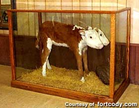
Just in case you didn't know, Fort Cody has a two-headed calf (fully mounted), and some big fiberglass animals: 2
buffalo, a grizzly bear, and a colt. We also have a hideous 8-ft. tall kachina that someone made out of metal.

NELIGH - Michael Landon Suite/Deluxe Motel
Located in Neligh, NE, the Deluxe Hotel's claim to fame is that on July 2-July 3, 1962, TV superstar, Michael Landon
stayed in room #10. After he checked out, the staff noticed a large hole in the wall Mr. Landon negleted to tell them about.
In disgust, they put up a note stating that the hole was made by the Hollywood star. The note has been replaced by a plaque
and the hole still remains.....
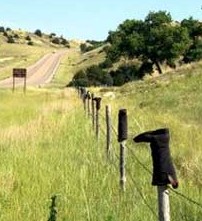
NORTHPORT - Shoe Fence
Between Northport and Ogallala on Highway 26 in Nebraska there is a fenceline that runs for miles and miles -- footwear
of all kinds are mounted upsidedown on the fenceposts on the right hand side of the road as you are travelling east/south.
Cowboy boots, tennis shoes, all manner of foot gear...and it goes on for MILES. If this were done by a single individual,
even at 50 cents a pair at a thrift store, this was an expensive project. Mystery?
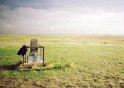
MINDEN - German POW Urinal
The sign above the urinal indicates it was salvaged from a WWII prisoner camp in Atlanta, Nebraska. A quick glance at a
map of central Nebraska will show you that Atlanta, Nebraska, isn't too far from Minden, Nebraska -- home of tourist icon Harold
Warp's Pioneer Village . The urinals are located in the adjacent Pioneer Village Campground.
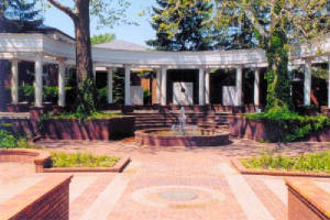
OMAHA- Gerald Ford Birthplace & Betty Ford Rose Garden
In Omaha, there is an interesting little area, where former President, Gerald Ford was born. He only lived in Omaha
for one year but the site where his parents' house once stood is now a memorial to the former president. There is
also the Betty Ford Rose Garden, which includes busts of Gerald and Betty, and there is a little gazebo-like structure, which
has some of Ford's personal belongings behind glass, with a button you can press to hear him speak about himself and his birth
site. Included behind the glass are some pens and ashtrays from the Oval Office when he was there, plus a set of his golf
clubs, and so on. Also, on land adjacent to the birth site, there is a small museum, and center for restoring and storing
historic documents.
Address: 1326 32nd St, Omaha, NE -32nd and Woolworth, near Hanscom Park.
Hours:Various, usually closes around sunset. (Call to verify)
Phone: 402-444-5955
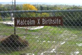
OMAHA- Malcom X Birthplace
Address: 3448 Pinkney St., Omaha, NE
Directions: The birthplace is now an open patch of land between 36th and 34th Sts
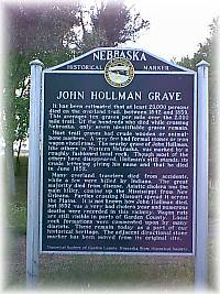
OSHKOSH- The Hollman Grave Historical Marker
It has been estimated that at least 20,000 persons died on the overland trail between 1842 and 1859. This averages ten
graves per miles over the 2,000 mile trail. Of the hundreds that died while crossing Nebraska, only seven identifiable graves
remain.
Most trail graves has crude wooden or animal-bone markers. A very few had formal stones or iron wagon wheel
rims. The nearby grave of John Hollman, like others in western Nebraska, was marked by a roughly fashioned local rock. Though
most of the others have disappeared, Hollman's still stands, its crude lettering giving his name and that he died in June,
1852.
Many overland travelers died from accidents, while a few were killed by Indians. The great majority died from
disease. Asiatic cholera was the main killer, coming up the Mississippi from New Orleans. Parties crossing Missouri spread
it across the Plains. It is not known how John Hollman died, but 1852 was a very bad cholera year and numerous deaths were
recorded in this vicinity. Wagon ruts are still visible in parts of Garden County. Local rock formations were commented upon
by many diarists. These remain today as part of our historical heritage. The adjacent directional stone marker has been moved
from its original site.
- Nebraska State Historical Society
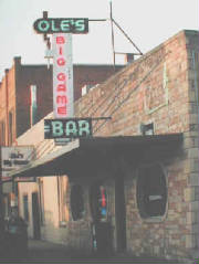 PAXTON - Big Ole's Game Lodge
Paxton is like every other Nebraska town situated around a water tower and a grain elevator. However, in the middle
of town is a little lounge called Ole's. It is decorated with mounted big game. It seemed that Ole, who has since
died, was a big game hunter. He started the bar just after prohibition (or possibly during it!) in the 1930s. He hunted extensively
in Africa and South America in the 40s, 50s, and 60s as well as deep sea fishing, and the bar was his base of operations.
He had amassed an incredible collection of stuffed game animals including a full size polar bear, lion and elephants heads,
and any other politically incorrect oddity. In addition, he has hundreds of photos of celebrities who had visited the lounge.
SEWARD - Fourth of July
Named "America's Fourth of July City: Small Town USA" by Congress in 1973, the
town of 6,000 provides more than 100 activities, events and exhibits at its celebration, drawing 40,000 visitors throughout
the day. Many events are free, making the day very family-friendly. Held every year since 1868, the celebration is organized
by volunteer high school students.
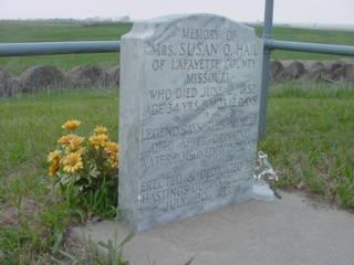
SHELTON- Susan C. Haile Gravesite
Susan Haile and her husband Richard were headed for California along the Oregon Trail, but in June of 1852 Susan died,
probably from Asiatic Cholera. The tombstone says "legend has it that she died from drinking water poisoned by the Indians".
It was common at the time to blame the Native Americans, but Indians were not in the habit of poisoning water.
Leaving
their six children in the care of an aunt, Richard returned to Missouri and had a proper tombstone made, then brought it back
to this spot. Vandals later detroyed that stone, but it has been replaced.
For years the story ended here and Richard
disappeared into the mists of history. But recently more information has surfaced. Now we know the correct family name is
actually "Haile", with an "e". Richard apparently caught up with the slow-moving wagon train and went on to the Napa Valley
of California. He farmed and engaged in lumbering, and he would be elected to the California state legislature three times.
He remarried and had four more children. Richard Haile died in 1890 after a long and productive life. We do not know if he
ever got back to visit the grave of his first wife.
Directions to the grave: On Interstate 80 in south-central
Nebraska, take the Shelton Exit (# 291) and go south on the paved road for 5.3 miles. It zigs & zags east & south,
but stay on the paved road for 5.3 miles. You will see The Susan Hail historical marker on the east side of the road; Immediately
south of it is a gravel road called 70th St. Take it to the east for perhaps 1/4 to 1/2 mile; you will see the grave on a
small hill on the north side of the road.
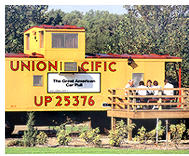 WATERLOO - Sleep in a Union Pacific Caboose
In Two Rivers State Recreation Area, near Waterloo, Nebraska, you can rent a cabin which used to be a Union Pacific caboose.
The cabooses have been fixed up, nicely, complete with bathroom, kitchen, and sleeping areas.
(Sleep in a Union Pacific Caboose: Waterloo, NE Directions: About 15 miles west of
Omaha, at Waterloo, Nebraska. )
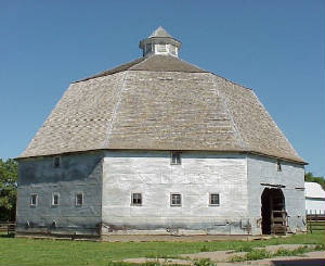
UEHLING - Uehling Round Barn
The Uehling Barn is located on a hill overlooking the town of Uehling. The prominence of the structure and its location
have made it a local landmark since it was built in 1918. The wood-frame barn is one of a small number of "round" barns in
Nebraska. Its builder, Frank Theodore Uehling, was the son of Theodore and Catherine Schwab Uehling, emigrants from Germany.
Theodore platted the town of Uehling in 1906. After attending the University of Nebraska College of Agriculture, Frank Uehling
established a stock farm, which became a model and the center of pure-bred livestock raising in Dodge County.
 VALENTINE - Cowboy Poetry Gathering/Old West Days
This four-day event is held the first weekend in October in Valentine, Nebraska.
Daytime poetry reading sessions are free and open to anyone with a poem to read or a song to sing. Participants need not have
cowboy backgrounds, but there is always a contingent of authentic cowboy poets eager to share their experiences through poetry.
Featured professional poets and musicians are heard in two evening performances, and there is a music and yodeling performance
Saturday afternoon. A special children's poetry reading is held, along with a workshop in western culture for children. Other
featured events include an old-fashioned melodrama performance, a Native American powwow, a western art and trade show, a
display of bit and spur collections, a mountain man rendezvous, an all-horse parade, and a trail ride. Cowboy Poetry
Gathering (Old West Days)
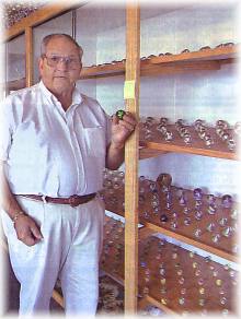
YORK - Lee's Legendary Marbles and Collectables
Lee Batterton's collection of hand-made marbles come in all colors and sizes and date from the late 1800s to early 1900s.
They have picturesque names like Peppermint Swirl, Clam Broth, Brick, and Indian Skin. Batterton's favorite is the rare Lutz
marbles with gold-colored powder inside. Glass cases lining two long walls display the more expensive ones, while, overhead,
hundreds of quart jars filled to their brims with agates add a colorful border. There are marbles in vases, huge glass containers
and trays.
Perhaps the most unusual ones are the pre-World War I ones containing uranium. Another display case holds machine-made
marbles with names like Corkscrews, Ketchup and Mustard, and Superman.
"There's hundreds of different kinds of marbles. Many of them came from Germany. But some of the ones I've got, no one
knows where they came from, who made them. There's still research going on and books being written about them."
Also featured are marble games, artwork, and information about the different kinds of marbles, their value, and where they
were made. Some of the marbles, along with coins and other antique items are for sale.
Location: 3120 S. Lincoln Avenue, York Nebraska
Admission: $4.00 Adult, $2.00 Children 12 and under - $10 Family Rate (Museum Only)
Hours: Tuesday through Sunday
Nebraska treasures waiting to be found
| |
Jesse James is said to have hidden loot here and there, such as at Devil's Nest
near Crafton, Knox County. |
|
$40,000 stolen from a bank in Kearney is believed to be hidden near Sargent, Custer County. |
| |
Gold miners returning from California were robbed near Lexington, Dawson County, and
their treasure buried in the area. |
| |
Robbers' Cave near Macy, Thurston County, may contain much treasure. |
MORE NEBRASKA LOST TREASURE
GOLD HUNTING
Although not known for great gold deposits, gold can still be found in various locations in Nebraska. Gold is best in areas
where there is an "ancient" or old river channel. It is usually fine gold.
Gravelpits: One must have permission, but in years past some people were able to find several oz of gold
a year by sluicing the discharge sands from gravelpits. Heavy black sand can often be found at these pits, especially in Western
Nebraska.
North Platte River: Very fine gold has been found at various locations along the North Platte.
Platte River: Gold has been found at various locations along the Platte River.
Red Willow County: Check waterways, streams, creeks, and other bodies of water in the area.
South Platte River: Gold had been found between North Platte and the Colorado border along the South Platte.
Nebraska Ghost Towns
Nebraska's Ionia Volcano
|